The scale of the Himalayas makes them the ultimate trekking destination
for nowhere else is such exalted beauty matched with such overwhelming remoteness.
The sweeping arc of this mountain chain provides goals for every visitor
and in its unity it displays an amazing variety of landscapes and a dazzling
selection of contrasting scenes, climates and cultures.
Trekking routes sometimes trace the footsteps of millions of pilgrims who
for hundreds of years have journeyed these trails to pay homage at
'religious shrines located high in the Himalayas. Others follow more remote
routes, cut off from civilisation, across some of the most exciting
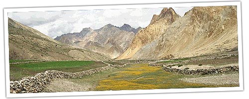
terrains.in the world. Across five Indian states spread the mighty Himalayas
and compressed in this expanse is the widest montanic geographical variety.
Wide, sweeping valleys and deep gorges give way to thick deciduous forests
and alpine meadows; undulating tea gardens and sombre slopes bar narrow
terraces, -looking like gigantic staircases flung down the mountains; and
gently contoured hills and imposing, snow-draped peaks surrounded by a fluff
of -clouds look down upon thundering rivers and deeply fissured glaciers. In
the Himalayas, time, like the terrain, is infinite. Grand and majestic, they
impose upon mind and heart, and the silence of wilderness dignifies their
remoteness.
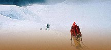
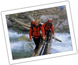
There could be no better way of exploring the natural
wonders of the Himalayas than in the most natural way - on foot. Stretching
for almost 1,000 miles, the world's youngest and loftiest mountains are a
treasure house of life. Remote civilisations and unique floral and faunal
systems thrive here protected by the folds of the mountains and preserved
from the onslaught of modernisation. Through the ages, travellers, ascetics
and sages have established a network of mountain trails connecting remote
parts of these fascinating mountains to the rest of the world.
Well-developed infrastructure facilities now offer these trails to all those
who have the will to go, the curiosity to seek and the ability to walk.
Geologically, the Himalayas are still young and growing, said to have been
formed only 60 million years ago when a travelling crust of earth from the
South Pole collided with Laurasia, folding up the Himalayas. Today, this
great mountain system plays an invaluable role in determining the quality of
life on the subcontinent. The mountain range controls the climate of India
by holding the monsoons till the appropriate time and protecting the land
from the winds of the cold Siberian winter. The snows from the Himalayas
feed the perennial northern rivers assuring water and farmland irrigation.
The climatic and geological diversity of the Himalayas has led to the
creation of an unique eco-system which holds a rich wealth of natural
resources, both living and non-living. The sharp zoning in vegetational
types and the resultant habitats are the home of a large assemblage of birds
and animals. Himalayan flora is unique. It encompasses forests of all types
- tropical swampy forests, decidious forests, coniferous forests,
rhododendron forests, alpine meadows and even hot and cold deserts.
PREPARING
FOR A TREK The Himalayas are criss-crossed by a complex network of
mountain trails that offer access to remote civilisations and areas of
unsurpassed natural beauty. The success of a Himalayan trek can depend
largely on your physical fitness, proper equipment and how well prepared you
are to venture into unknown areas inhabited by people whose culture and
language are foreign to you.
Most Himalayan treks demand six to
eight hours of walking every day. At different altitudes and gradients, this
can be a trying task for the physically unfit. It is therefore, best to tone
up your body systems by exercising for at least an hour and a half every day
for three months before you start your trek. Short forays into trails in
your &! neighbourhood will also help your body familiarise itself to
strenuous walking.
 How
to Trek
How
to Trek You can plan to trek in four ways: alone; with a porter;
with a sardar and a crew; and through a travel agency. Trekking alone is not
usually recommended as you will be travelling in unfamiliar areas and will
find it difficult to communicate' with local villagers without knowing their
language. Porters can usually be hired from small towns and villages at the
base of the trekking trails. The porter will help you carry your baggage,
communicate with the locals and often enlighten you with stories and lore
about the region. Hiring a sardar and a crew is more expensive but worth the
money if you want to leave yourself free from all logistical problems. Try
and find a sardar who has trekking experience and testimonials to prove it.
The sardar will in turn hire the cook and the porters and arrange for the
provisions required enroute. Travel agencies are the most professional and
expensive trek handlers. They will normally take care of all travel
requirements including air ticketing and transportation leaving you totally
free to enjoy your walking expedition. Your closest Government of India
Tourist Office, and local tourist offices in the trekking areas, will be
able to help you select a reliable travel agency and also advise you on the
prevailing porter and sardar rates.
Trekking in the Himalayas does
not require a permit as long as you do not enter restricted areas or cross
the protected area beyond the inner line. Survey Of India maps, available at
their office at Janpath in New Delhi, define the restricted areas and are
invaluable assets to the trekkers as they clearly indicate most mountain
trails, altitudes and gradients. Mark your trail on the map in advance to
ensure that you do not branch off on the many subsidiary trails that radiate
from the main route.
Climate Climate in
the Himalayas is primarily dependent on two factors: elevation and time of
year. In any season, be prepared for extremes in temperature, from the very
hot to the very cold. Many trekkers come prepared only for winter conditions
and sweat it out because of inadequate light clothing at the lower
altitudes. Though the monsoons normally break on the subcontinent by mid
July and abate by September, localised thunderstorms can occur anywhere in
the mountains, particularly during spring and summer, so come prepared with
enough waterproof clothing and protection. Autumn is the best time to trek
in most areas but March, April and May are also good months.
Equipment
It is best to prepare your trekking kit and equipment before you arrive in
India as it is not always possible to get what you want at the time that you
want it. You are the best judge on what you should carry in terms of
personal gear and camping equipment as this would depend largely on the area
that you are trekking in. As a basic guideline, some of the items that you
might consider taking are listed below:
Clothing
and Personal Gear You will require clothes for yourself as wel1 as
some to give away to your porter. As far as possible carry only those
fabrics that can be easily washed in the cold water streams enroute. Some
suggested clothing: underwear three pairs: swimsuit - for women to bathe in
vil1age streams: socks - take quite a few liner socks in addition to three
sets; walking skirts for women - shorts can often offend local villagers and
skirts are a good and comfortable alternative; t-shirts - three pairs;
lightweight shirts - two wash and wear pairs; walking shorts - one pair;
trekking pants - one pair of loose baggy trousers that al10w freedom of
movement to the legs; jacket - one; trekking boots - make sure they are
broken in and are of good quality; insoles - to prevent foot fatigue; tennis
shoes-one pair for the time when you want to rest your feet; gloves;
umbrel1a; hat; money belt; handkerchiefs - three; poncho and ground cloth -
necessary protection against wet weather; sleeping bag; sleeping sack.
Camping
Equipment You will not need to carry a tent or a foam pad if you
are trekking in a group or plan to sleep only in houses and in inns. A tent
will, however, give you the option of camping on any spot close to water.
Cooking Equipment Cooking equipment wil1
be required only if you are planning to trek on trails that do not have inns
and if you are not hiring the services of a sardar. Most cooking equipment
can be bought local1y though it is often not as light as that manufactured
in Europe and America. You will require the fol1owing basic equipment:
stove-kerosene stoves function best at high altitudes and fuel is easily
available; fuel container should be light and sturdy; nesting cook pots - a
minimum of two will be required; stuff bags - to carry provisions; freeze
dried foods.
In addition, it wil1 be handy to carry the fol1owing
miscel1aneous items: backpack, medicine kit, maps, notebook, toilet kit,
toilet paper, watch, enamel cup, spoon, can opener, pocket knife, scissors,
flashlight, water bottle, sewing kit, boot protector, lip balm, suntan
lotion, cord, sunglasses, insect repel1ent, and bug powder.
Photography Most trekkers would like to record their trip on film.
Himalayan treks offer a wealth of photographic possibilities and carrying a
little extra photography equipment can be worth its weight. Single reflex
cameras with interchangeable lenses are most suitable for the situations
that you wil1 encounter. Lenses should include a wide angle (28-35mm) for
buildings and landscapes, a telephoto (70-200) for unobtrusive portraits and
close-ups of mountain peaks. A macro lens wil1 help you photograph flowers
and insects of the Himalayas. A light tripod wil1 be handy in situations
with low light. Carry plenty of film as you will probably end up taking more
photographs than you planned (a roll a day should suffice). Make sure you
have waterproof covering for your camera equipment and extra batteries. You
wil1 need an ultra violet and a polarising filter for high altitudes.

HIMALAYAN NATURAL HISTORY The Himalayas are a biological
wonderland, encompassing a variety of forest types and faunal assemblages.
Within the Himalayas, biologists recognise a number of vertical and
horizontal zones which result in a distinctive habitat for a variety of
birds and animals. Horizontal zoning occurs primarily due to the yearly
monsoon that moves northwestward from the Bay of Bengal, rapidly dissipating
moisture. Consequently, animal and plant life vary from one part of the
Himalayas to is the other, even though they are at the same elevation.
Vertical zone result from the changes in temperature and moisture with
increasing elevation. In general, the temperature drops about 6°C for
every 3,400 feet rise in elevation. Plant and animal life is also determined
by the location of the permanent snow line, the height of which depends on
summer temperatures, amount of snowfall and exposure, fluctuating greatly
even within the same zonal range.
Aeolian Zone
This zone normally occurs above 15,000 feet and covers the area above the
snow line. Because of the harsh climatic condition flowering plants are
absent here and life is limited to bacteria, fungi, insects and crustaceans
that subsist upon airborne food particles. Much of the ground is exposed in
this zone as snow seldom accumulates here.
Alpine
Zone This zone, depending on the region, is found between 9,000 to
15,000 feet and covers the belt between the timberline and snowline and is
characterised by harsh winters, short summers, shallow soils, strong winds
and lack of moisture. In the upper limits of this zone a few pioneering rock
plants like stonecrop, rock jasmine and primroses manage to brave the lack
of moisture. Plants like eidelweiss and sow's ear are also found in this
upper belt.
The pride of the alpine zone are its. meadows. Covered
with lush grass, they support a profusion of colourful wild flowers. This
spectacle is most evident in grassy meadows where snow melt collects and
where deeper soil has developed over the ages. Some of the flowering plants
of the Himalayan alpine meadows are; buttercups, anemones, larkspurs,
everlasting flowers, asters, dandelions, thistles, saxifrages, cinquefoils,
louseworth, geraniums and gentians. A flower worth looking for in the
meadows is the magnificent blue poppy, also referred to as the Queen of the
Himalayan flowers.
Alpine scrub is usually found around streams
and in U-shaped valleys. The main plant species here are rose, marmon tea,
juniper and several species of rhododendrons.
Animals in the
alpine zone are mostly Eurasian species that have the ability to adapt to
the severe conditions of the northern latitudes. Mammalian species include
bharal, pikas, marmots, red fox, weasel, moles, mice, lynx, wolf, brown bear
and ibex. Many species of birds also breed in the grassy alpine meadows.

Sub-Alpine
Zone The sub-alpine zone, usually between 9,000 to 12,000 feet, is
a transient buffer between temperate coniferous forests and the alpine belt.
Short, stunted and windblown birch, juniper and rhododendron plants dominate
this area. In the north-west Himalayas, rhododendrons are replaced by
sagebrush, poplar and willow trees while the rest of the area has a
distribution of fir, pine or spruce trees.
The main mammalian
species of this zone are the rapidly dwindling musk deer and the aboreal
birch mouse found in birch forests.
Temperate
Zone The temperate zone, between 6,000 to 10,000 feet is an almost
continuous forest belt. The flora and fauna of this zone is truly Himalayan
in composition. The upper areas of this belt are characterised by conifers
such as fir, hemlock, pine, cypress and cedar. Undergrowth is mainly sparse
comprising of rhododendrons, bamboo and other scrub species.
Temperate evergreen forests are found between an elevation of 3,000 - 5,000
feet in some Himalayan areas. Almost pure stands of evergreen oaks
interspersed with laurels, chestnut, maples and magnolias are found here.
Near streams and in ravines where water is available in plenty, numerous
wild flowers, ferns and orchids grow.
Forests in the temperate
region in Kumaon and parts of Kashmir consist mainly of oak and blue pine,
and in the west Himalayas of fir with some deodar. The north-western
Himalayas are arid to semi-arid at this altitudinal zone. As one climbs
higher, conifers become more abundant. In the western Himalayas coniferous
forests are dominated by the five needled blue pine and the west Himalayan
fir. Other tree species include the magnificient deodar and the west
Himalayan spruce. East Himalayan fir grows from Kashmir to Bhutan in an
almost continuous belt. Another pine species which thrives in the central
and western Himalayas is the chir pine.
The fauna of the temperate
zone is diverse and unique. Large mammals that inhabit this belt include the
goral, serow, and the Himalayan tahr. Langur monkeys, Himalayan black bear,
yellow throated martens, leopards, red pandas and a variety of smaller cats
are also found in large numbers. The greatest variety however, is in the
avifaunal assemblage of this region. From the forest floor to the top of the
canopies, a menagerie of birds thrive. Laughing thrushes, munias, nut
hatchers, tree creepers, tits and warblers are present in abundance.
Tropical
and Sub-Tropical Zones Tropical and sub-tropical forest zones are
usually found between 150 to 6,000 feet and occupy the hills boundering the
lowlands of the eastern and central Himalayas. The canopies in these forests
are made of many deciduous and evergreen hard woods like sal, teak and
bauhinia. Sal is however, the major species and forms an almost continous
belt at the base of the Himalayas.
Tropical forests are taken over
by sub-tropical montane forests at an elevation of about 4,500 feet. Common
trees in the area include chestnut, schina, horse chestnut and walnut. Oaks
are alos in plenty and alders grow along drainages.
UTTARAKHAND
Uttarakhand covers an area of 18,350 sq miles in the central Himalayas and
encompasses the areas of Kumaon and Garhwal in the state of Uttar Pradesh.
Characterised by thickly wooded terrain forests, arid zones and high
altitude tracts, Uttarakhand offers a diversity of natural features and
animal and plant life. Adding to the geographic variations are picturesque
townships and hill resorts and some of the holiest spots in India. The most
important destinations of Hindu pilgrimage, the temples at Yamunotri,
Gangotri, Kedarnath and Badrinath are visited by scores of devotees. Infact,
the earliest travellers to these mountains were sages and ascetics in search
of peace and tranquility. Uttarakhand comprises of four hill districts and
three border districts.

Trekking routes in Uttarakhand are not restricted to any particular areas.
The entire mountain system offers exciting trails which originate at staging
points spread over the entire length and breadth of Uttarakhand. Gangotri,
at a height of 3,140 metres, is the source of the river Ganga. It is at this
spot, Hindus believe, that the Ganga descended on earth from heaven.
Gangotri is accessible by road from Rishikesh but trekkers prefer to trek
the route. The trek takes 14 days and passes through important towns like
Uttarkashi, Gangnani and Lanka. A popular trek from Gangotri is to the holy
shrine of Kedarnath, one of the five important religious centres in the
area. This is an old pilgim route which takes 7 days and passes through lush
green meadows called bugyals which are dotted with colourful flowers in the
rainy season.
From Rishikesh, a holy town which is the staging
point for the trek to Gangotri, trekkers can also attempt the
Khatling-Sahsratal-Masartal trek which takes seven days and passes through
thick forests and lush green meadows. The Khatling glacier is a lateral
glacier, the centre of which is the source of the river Bhilangana. Another
popular glacier trek from Rishikesh is to Pindari Glacier.
Pindari
is one of the most easily accessible of all the Himalayan glaciers, nearly
three kilometres long and a quarter kilometre broad. The trek to Pindari
takes 5 days and passes through pine forests, wild flowers, undulating
meadows and gurgling brooks.
Nanda Devi is a natural sanctuary for
a variety of Himalayan animals and birds. The sanctuary, now protected by
law, is guarded by over 70 snow covered mountain peaks which include that of
Mt. Nanda Devi. Nanda Devi Sanctuary is at an altitude of 4,500 metres and
is approachable from Joshimath after a 10 day trek. Another famous trek from
Joshimath is to the Valley of Flowers. Described as one of the natural
wonders of the world, the Valley of Flowers is 10 km in length and 2 km in
width and shaped like a cone. This alpine valley nestling in the shadow 10
of snow peaks has several clear running streams with banks full of lush
vegetation. During the monsoon, the entire valley becomes a vast natural
garden blooming with an innumerable variety of alpine flowers. The valley,
which varies in altitude from 3,500 metres to 4,000 metres, is now preserved
as a national park. The trek from Joshimath to reach the Valley of Flowers
can be extended to the holy Sikh shl1ne of Hemkund Sahib.
Har-ki-Doon is situated in the western ranges of the Garhwal Himalayas, at
the base of the Fateh Parvat, at an elevation of 3,556 metres. This cradle
shaped valley, which is surrounded by dense forests of pines and glittering
mountain peaks, is a paradise for bird watchers and nature lovers. It takes
9 days of walking from Mussoorie, a township built during the days of the
British Raj, to reach Har-ki-Doon. It is also possible to approach Nag Tibba
peak (3,048 metres) from Mussoorie on a 5 day trek, and then to Nainbagh
through rich forests teeming with wildlife.
The Uttarakhand region
also has other interesting and challenging trekking trails like the 4 Gays
trek from Uttarkashi to Dodital, a high altitude lake at 3,024 metres. The
Kuari Pass Trek, also known as Curzon's Trail, is extremely scenic and
passes through the heart of the Chamoli district of Uttar Pradesh. Peaks
visible from Kuari Pass include Nanda Devi, Dunagiri, Bethartoli and
Devasthan. Almost every region of Kumaon and Garhwal has its own passes and
trails that differ not only in scenic splendour but also in the lifestyles
and cultures of the people that inhabit these areas.
Gangotri-Kedarnath Trek This 180 km long trek
through some of the most beautiful locales of Uttarakhand follows an old
pilgrim route. The trail originates at Gangotri, the source of the Ganga,
and backtracks till Bhatwari from where the 'actual trek be gins. Gangotri
was the actual source of the Ganga in the Vedic ages but the river has
receded 19 km to Goumukh which is said to have been created by Lord Shiva to
represent the flowing body of Lord Vishnu, swaying to the music of Lord
Shiva. The 250 year old temple at this spot which was crafted out of stone
carried from a quarry almost 20 km away is a place of pilgrimage. Mountain
peaks visible from Gangotri and Goumukh include Shiv ling (6,543 meters),
Sudershan Parvat (6,507 meters), Bhagirathi Peak, Sri Kailash and Vasuki.
The trek is long and exhausting but offers glimpses of life in the villages
and some of the most beautiful ridges and meadows in Uttarakhand. Some of
the meadows which the trekker passes through and which are known for their
beauty are Kush Kalyani, Panwali, Kuini and Tali. These lush meadows are
covered with a variety of wild flowers and fringed by dense forests of oak,
rhododendron and pine.
Kedarnath is said to be the abode of Lord
Shiva. He is said to have taken refuge here in the form of a buffalow while
escaping from the Pandavas who were seeking him to beg absolution after
having killed the Kauravas. Besides the main shrine, there are many
interesting temples in the Kedarkhand area. An hour's steep trek from the
main shrine also leads to the Chandrashila Peak at 3,930 meters with
excellent views of the Himalayan panorama.
Season: June to
September
Grade: Difficult
Duration: 9 days
Stages: Gangotri to Mala (73 km by
vehicle), Mala to Sauri-ki-Gad
to Phyalu to Chunachatti (11 km), Chunachatti to Belak to Pangrana to Jhala
(13 km), Jhala to Agund to Bhaironchatti (9 km), Bhaironchatti to Gaunanda
(13 km), Gaunanda to Dhuphanda to Panwali to Kyunkholakhal (10 km),
Kyunkholakhal to Sonaprayag to Gaurikund (15 . km), Gaurikund to Kedarnath
(14 km), Kedarnath to Sonaprayag (29 km).
Dodital
Trek Dodital, at 3,024 meters, is one of the loveliest lakes in
Garhwal. Surrounded by lush meadows abundant in wild flowers, and deodar and
pine forests, the lake also offers excellent opportunities for trout
fishing. The water of the lake is crystal clear and the neighbouring forests
abound in wildlife. From a ridge just above Dodital, the trekker has an
excellent view. The last
stages are quite steep and arduous.
Season: June to September
Grade: Moderate Duration: 5
days
Stages: Uttarkashi to Gangotri (4 km by vehicle), Gangotri
to Kalyani (7 km by jeep), Kalyani to Agora (5 km), Agora a Dodital (16 km).
Note: Hotels and travellers lodges at Uttarkashi. Forest rest houses at
Agora and Dodital.
Har-ki-Doon Trek For
nature lovers, Har-ki-Doon Valley at 3,566 metres offers rich jungles
abundant in bird and animal life, a variety of alpine flowers and plants,
and spectacular views. Part of the Fateh Parvat in western Uttarkashi,
Har-ki-Doon is a cradle .shaped valley south-east of the Janundhar glacier.
It is surrounded by snow covered peaks and in the southeast by heavily
wooded forests.
The trek to Har-ki-Doon initially runs along the
Supin river with an excellent view of the Supin valley and Fateh Parvat. It
then passes through jungles of chestnut, willow and walnut, and the trekker
may come across jungle fowl and partridges in the area. The last stage of
the trek is through terraced fields, lush grasslands and coniferous forests.
It is particularly rewarding to trek to Har-ki-Doon soon after the monsoons
when the valley is in bloom with a variety of colourful alpine flowers.
Season: June to September
Grade: Easy
Duration:
7 days
Stages: Dehra Dun to Mussoorie (36 km by vehicle),
Mussoorie to Purola (97 km by vehicle), Purola to Jarmola (22 km), Jarmola
to Mori (16 km), Mori to Netwar (12 km), Netwar to 12 Saur (12 km), Saur to
Taluka (12 km), Taluka to asia (11 km), asia to Harki-Doon (8 km).
Curzon
Trail (Kuari Pass Trek) One of the most interesting treks in the
Garhwal area, this route was chosen by Lord Curzon, a viceroy of imperial
India and therefore, is often referred to as Curzon Trail. The trek passes
through forests of oak and conifer, bamboo and birch, teeming with a variety
of animal and bird life: A trekker might even be lucky enough to come across
leopard pug marks or a Himalayan black bear on this trail. Kuari at 4,268
meters, offers a spectacular view. On the northeast it is fringed by the
towering Himalayas and in the south-east by lush valleys and meadows.
Season: June to September
Grade: Easy
Duration:
10 days
Stages: Nandprayag to Ghat (19 km by vehicle), Ghat to
Ramni (to km), Ramni to Sarkot (4 km) Sarkot to Jhenjipani (9 km),
Jhenjipani to Panarani (12 km), Panarani to Sanatoli (5 km), Sanatoli to
Domabhiti (5 km), Domabhiti to Kuari Pass (5 km), Kuari Pass to Auli (24
km), Auli to Joshimath (8 km).