The Inspiring Himalayan
Peaks of U.P. Hills
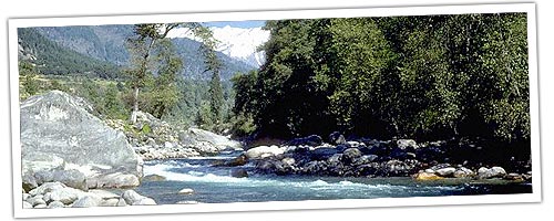
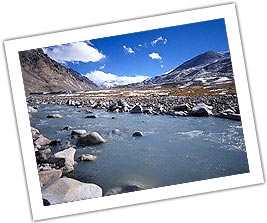
The Central Himalaya are the crown of Uttar Pradesh and stand guard to the
Upper Ganga plain. The mighty Himalayas standing on the northern frontier
of UP are highly rugged and have difficult and precipitous slopes, horned
peaks, serrated crests of high ridges, cirques and glaciers, snow clad slopes,
hanging valleys, cascades of sparkling water supplied by melting ice, torrential
rapids, deep canyons, roaring streamlets, huge boulders and glistening lakes.
When one happens to be in these environs, a deeply hidden longing becomes
very pronounced upon gazing at the Himalayan peaks of Uttar Pradesh... the
longing to reach up to those awe-inspiring, wonder-filled and dizzy heights
that exude a joy on their own.
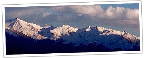
These cloud-kissing, skyscraping peaks tower serenely above all else creating
a picture as only the most adept of all artists: Mother Nature could paint.
The scenic beauty and the grandeur of the Central -Himalayan ranges and
the remote location of the religious temples like Badrinath, Kedarnath,
Gangotri and Yamunotri have excited the interest of people since very early
times. In the Pauranik literature, this part of the Himalayas bears the
name of Uttara-Khand or Kedar-Khand. Ved Vyasa being attracted to the scenic
beauty and religious importance of this region wrote an Upa-Purana about
it.
The region and especially the peaks are abundantly referred to in historical
literature, indicating that great saints, travellers and kings frequently
visited this part of the Himalayas. In fact every peak, rock and rivulet
is dedicated to some deity or saint and has an appropriate legend attached
to it.
HIMALAYAN PEAKS OF UP HILLS
The lofty Himalayan peaks rising to dizzy heights have a complex physiography
falling into three regions. The topography of rugged land and dangerous
slopes have often beckoned the spirit of the adventurers. No wonder, many
of the peaks have been successfully scaled by mountaineers from the world,
over the years.
U.P. Himalaya includes the Himalayan basins of the Yamuna, the Ganga, the
Ramganga and the Kali or Sarda. The tangential as well as vertical movements
of the terrain have given rise to complex physiography of the region. Thus,
the topography consists of highly rugged land with precipitous slopes which,
in accordance with its structure and relief, is further subdivided into
3 major physiographic regions.
1. Himadri (Greater Himalaya)
i) Himadri Ranges
ii) ii)Himadri Valleys
2. Himanchal (Lower Himalaya)
i) Himanchal ranges and hills.
ii) ii)Himanchal valleys and lake basins.
3. Shivaliks (Sub-Himalayan tract)
i) Duns
ii)Shivalik ranges
HIMADRI
Himadri, the great Himalayan zone forms the northern boundary of the region
stretching in North West South East direction, the average width of the
Himadri is about 50 kms. The average altitude of the zone varies from
4,800mts. to 6,000 mts. The important peaks of this region are: Nanda Devi,
Kamet, Bander Punchh, Kedarnath, Chaukhamba, Dunagiri, Trishul and Nandakot.
Almost all these peaks are glacier-garlanded and are separated by transverse
gorges of the Alaknanda, the Bhagirathi and the Dhauli Ganga. The important
glaciers of the Kumaon Himadri are: Gangotri, Chaturangi, Bhagirathi,
Kharak, Satopanth, Kamet, Milam and Pindari.
HIMANCHAL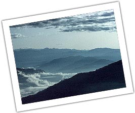
The central zone of the Himalaya located between the Himadri and the
Shivaliks in the north and south respectively, is known as the Himanchal.
With an approximate width of 75 kms, the Himanchal is a massive mountainous
tract, separated in the south by the 'main boundary fault.' The whole zone
is mainly composed of metamorphic rocks varying in age. The average height
of the ranges in this zone varies from 1,500 mts. to 2,700 mts. and of the
valley bottoms between 500 mts. and 1,200 mts.
Most of the valleys
of the important rivers form a wide course. The rivers cut through barriers
to drain out lakes, such as the ones in the vicinity of Baijnath in the
Garur valley, Agastmuni (Mandakini valley) and around the basins of the Bhim
Tal and the Naukuchiya Tal in Nainital District.
SHIVALIKS A long chain of narrow and low hills, from 300 mts. to
600 mts. in elevation, lie almost parallel to the main ranges of the
Himanchal.
The hill slopes are steeper on the southern side while on
the northern side the slope is gentler and merged to flat floored structural
valleys called 'duns'. The important duns are Dehra, Kohtri, Chaukham, Patti
and Kota. The dun of Dehra (Dehradun) is the biggest with a length of 35
kms. And width of 25 kms.
SOME IMPORTANT PEAKS
Lord C. Schuster said of mountains "Always alluding, though they flout
you, always dear, though they slay you, they give you strength & friends
& happiness; & to have known them is indeed a liberal education. "
NANDA
DEVI Altitude: 7,817 mts.
Nanda Devi, the highest of
the Garhwal peaks, which literally means 'Blessed Goddess'. It is considered
the pearl of the Himalayas because of its loveliness. The graceful symmetry
of its double peaks, the main and the east, thrusting themselves up to the
sky, is indeed a visual treat-a rare example of perfect twin peaks. It would
perhaps be strange if a mountain of such beauty were not an object of
worship. In fact, since ancient times, inhabitants of the region have
revered this mountain as a dwelling place of the Gods. The names for
mountains and passes in the area often have religious meanings.
Like Kamet, Nanda Devi refused for years to yield to the many climbers who
tried to overcome her. It is extremely difficult even to approach her
foothills, the entrance to which is guarded by long, deep gorges. After
several failures, one party finally succeeded in crossing these gorges and
in 1934, entered the south foothills of the mountain.
BANDAR
PUNCHH WEST (White Peak)
Altitude: 6,316 mts.
This peak lies to the South West of Kalanag. In June 1950 JTM Gibson with
Tensing Norgay (of Everest fame) attempted it from the south. They were
defeated by vertical walls of ice gullies. Once climbed after avoiding the
crevasses and on finally reaching the corniced top one can get a view of the
steep drop to the southern valley, adjoining ridge of Bander Punchh and
distant Swargarohinl peaks.
DEVTOLI Altitude:
6,788 mts.
The peak lies to the southern most point on the inner wall
of the Nanda Devi Sanctuary. It is on the South West ring of peaks in line
with Maikroli & Mrigthuni (6,803 & 6855 mts. respectively).
It is at the Junction where the ridge from the Devistan joins in the south,
the ridge between Maikroli & Mrigthuni. So it stands overlooking the
sanctuary in the east, Trishul Nala in the west & Sunderdhunga - Tharkot
directly below to the south.
Panchchuli Peaks
Altitude : 6,904 mts
It is believed that this is the place Five
chulis' cooking hearths) where the Pandavas cooked their last meal on the
way to heaven They are majestic and form a famous barrier between Darma and
Gori valleys. H. Ruttledge recceed it in 1929. Graaff and Snelson (1950),
the Scots (1950) made an attempt from this side. H. Harrer (1952) tried from
the west. Finally it was left to two massive expeditions by the Indo-Tibet
Border Police to open the route (1972) from the west (Gori valley) and make
the first ascent in 1973. On the same divide, a number of fine peaks merit
attention, like Nagling, 6,041 mts.
KAGBHUSAND
Altitude : 5,830 mts.
The historic triangulated peak of
Kagbnhusand seems to be guarding the entrance of Devban plateau. It has
graceful shoulders supporting a delicately soaring peak. The top has a shape
of Garud or eagle who is also referred to as Kagbhusand. This peak is seen
from a little above Gamsali, from Gupt Khal and even from the Girthi gorge.
TRIMUKHI PARBAT Altitude: 6,422 mts.
Trimukhi Parbat stands tall proudly to the southwest. The word literally
means mountain of three faces, a colloquial name for Lord Shiva. It has
sharp ice-pinnacle-like in shape. The possible approach can be via its
eastern col which has to be reached via a long detour from the Trimukhi
Glacier's southern bifurcation. Both the duration of the approach and the
technical difficulties of the final sections often rule out attempts.
TRIMUKHI
PARBAT EAST Altitude: 6,280 mts.
To the east of the
Trimukhi Parbat is a good shapely separate peak of Trimukhi Parbat East.
KAMET Altitude: 7,756mts.
Kamet taken
from the word Kangrie which literally means 'lower snows' in Tibetan
attracted the first mountaineers.
Kamet Peak is the second highest in
the Garhwal and was tried ten times before it fell. The eleventh and
victorious climb was headed by FS. Smythe of Britain. One of his companions
to the top, R.L. Holdsworth, wore skis up to the col, 7,025 mts. high.
In 1848 Richard Strachy determined its height, followed by the
Schlagintweits. In 1855 they went over the Mana pass and attempted it from
the north reaching 6745 mts. on Abi Gamin. In 1874-77 the Survey of India
under E.C. Ryall and LS. Pocock set up a plane-table at 22,040 ft on the
slopes of East Abi Gamin these are now identified on modern maps as Mukut
Parbat, Kamet and Abi Gamin respectively.
In fact in 1931, it was
while returning from their successful Kamet expedition that Frank Smith and
Holdsworth stumbled into the Valley of Flowers.
NEELKANTH
Altitude: 6,597 mts.
Nilkanth is a pyramidal snowy peak towering
above Badrinath. It is popularly known as 'Garhwal Queen' because of it's
dramatic sight. No history of Central Garhwal would be complete without a
detailed mention of this majestic peak. It is a name of Lord Shiva,
presiding over Badrinath and worshipped by millions of pilgrims. It is a
tough and challenging proposition for mountaineers.
NANDAKOT
Altitude: 6,861 mts.
This 'Fort of Nanda' is an imposing
peak dividing the Gori and Pindari valleys. It was recceed by Dr. Longstaff
in 1905 and in 1936 the Japanese made the first ascent. An Indian team in
1959 climbed it again. In 1986 the Indo-Japanese made another ascent to
celebrate the fifty years of its first ascent.
SUDARSHAN
PARVAT Altitude: 6507 mts.
Sudarshan Parvat has
beauty as well as challenge. It is a sight for the Gods. Situated above the
Gangotri temple it has been seen by millions of pilgrims and mountaineers
through the ages.
The view from the top is grand. All the Gangotri
peaks and valley, a little of Tibet and all the neighbouring peaks can be
seen.
CHATURBHUJ Altitude: 6,655 mts.
Sudarshan has two elderly neighbours. Both the peaks are hidden from view
and hence perhaps not known. Otherwise they are both as challenging.
Chaturbhuj, situated north of Sudarshan Parvat, literally means 'one with
four hands.' This is the name for Lord Vishnu who has four hands and holds
the Sudarshan Chakra. This peak has four distinct ridges falling in four
directions, thus both mythologically as well as topographically this name is
appropriate. The summit of Chaturbhuj is a conical pyramid, very steep, 15
mts. long and 2 mts. high.
YOGESHWAR Altitude:
6,678 mts.
Situated north-east of Sudarshan Parbat lies Yogeshwar. It
takes its name from Lord Krishna, in a serene mood and thus can be aptly
applied to this high snowy peak.
SAIFE Altitude:
6161 mts.
South-south-east of Sudarshan Parbat lies a gentle yet
deceptive peak. Saife in local language means 'sword' or the weapon carried
by Lord Ram, who is also known as the God with the white complexion
Swetvarn. This peak lies near Koteshwar 'God of the Edges'. Thus with sword
edge-like ridge, the name is appropriate.
CHANDRASHILA
Altitude: 3,679 mts.
Chandrashila is most accessible peak of the
U.P. Himalayas, especially since most of the peaks are difficult to scale. A
climb to this mini peak in Chamoli district is arranged by Garhwal Mandal
Vikas Nigam (GMVN). This combines scaling, skiing and trekking through a
route of rich flora and fauna, lies, meadows full of fresh snow in the
winter months. The Chandrashila peak itself provides a rare panoramic view
of innumerable snow clad peaks.
SOME IDEAL
PLACES TO VIEW THE MAGNIFICENT PEAKS.
In all this beauty I guess
God must be pretty close.
 BADRINATH
:
BADRINATH
: Guarded on either side by the two mountain ranges known as Nar and
Narayan with the towering Neelkanth peak providing a splendid backdrop.
Badrinath is one of the 'four dhams' of the country and is situated at an
elevation of 3,133 mts. above sea level.
KEDARNATH: A
scenic spot, situated against the backdrop of the majestic Kedarnath range,
the Kedarnath shrine is one of the twelve 'jyotirlingas' of Lord Shiva.
YAMUNOTRI :In the shadow of the high Bandar Punchh
mountain lies the source of the sacred river Yamunotri. At an elevation of
3,235 mts above sea level, this shrine is of paramount religious importance
for Hindus and an essential pilgrimage.
VASUKITAL :
Offering an excellent view of Chaukhamba peak, the Vasukital lake is
surrounded by high mountains and is situated at a height of 4,150 mts. above
sea level.
GANGOTRI: Surrounded by the mountain peaks of
Shivling, Satopanth and Bhagirathi sisters, this sacred shrine situated at
an altitude of 3,200 mts. is the source of the River Bhagirathi.
KEDARTAL
: The mighty Thalsagar (Spatikling) peak forms the spectacular backdrop
to the Kedartal Lake which is negotiable through a rough mountain trail.
NANDANVAN : From here tf1e views of Shivling, Bhagirathi,
Sudarshan, Thalu peaks and Kedar Dome are fabulous.
VALLEY OF
BHILANGANA : The Khatling Glacier is a lateral glacier at the source of
the River Bhilangana. Shastratal and Masartal are on the west and east of
it. The Valley of Bhilangana offers panoramic views of the snow capped peaks
and hanging glaciers, such as Jogin Group, Kirti Stambh and Meru Parbat
which are sublime and magnificient.
GUPTKASHI: From here
one can get a magnificient view of Chaukhamba peak.
MADMAHESHWAR:
Engulfed by Chaukhamba, Kedarnath and Neelkanth peaks, the trek from
Kalimath to Madmaheshwar is distinguished by wild unparalleled scenic
beauty.
RUDRANATH : The temple situated at an elevation of
2,286 mts. above sea level, provides magnificient views of Hathi Parvat,
Nandadevi, Nanda Ghunti, and Trishuli peaks among others. The face of Lord
Shiva is worshipped here.
HEMKUND SAHIB : Situated at a
height of 4,329 mts near the Valley of Flowers is the holy lake of Hemkund,
associated with Guru Gobind Singh. Encircled by seven snow-clad peaks and
their associated glaciers, the crystal clear serene waters of the lake
reflect the enchanting surroundings.
AULI : The cable car
from Joshimath to Gorson via Auli, offers a picturesque view of the
Himalayan ranges. 15 kms from Joshimath at an elevation of about 2,500
mts-3,050 mts. Auli is an ideal venue for winter sports.
PAURI
: Situated at an elevation of 1,814 mts above sea level on the northern
slopes of Kandoliya Hills, it provides a panoramic view of the snow clad
Himalayan peaks of Bandarpanch, Swarga-Rohini, Jonli, Gangotri Group, Jogin
Group, Thalaiya-Sagar, Barte Kanta, Kedarnath, Kharcha Kund, Sumeru,
Satopanth, Chaukhamba, Nilkanth, Gauri Parbat, Haathi Parbat, Dronagiri,
Nanda devi and Trishul.
GWALDAM Gwaldam is a sylvan
Himalayan quaint town surrounded by fruit orchards. One can have a
magnificant view ofNandaghunti, Trishul and Nanda Devi Peaks.
CHAUKORI
The charming and picturesque town of Chaukori is situated at an elevation of
20 I 0 mts. in the heart of Pithoragarh district, close to the famed Jim
Corbett Park. Chaukori is famous not only for the magnificent view it offers
of Panchchuli, but also for its breathtakingly beautiful sunsets.
PITHORAGARH
: The easternmost hill district of Uttar Pradesh, Pithoragarh is
often referred to as "Miniature Kashmir". It is situated at an
altitude of 1650 mts. above sea level. From the Chandak hill located at
around 2000 mts., one gets a Himalayan scenery comes alive. The view of the
snow covered Trishul and Nanda Devi is so clear that one gets a feeling of
the snow being within touching distance.
MUNSIYARI : The
centre as well as the Gateway of Johar region, situated at an elevation of
2289 mts. Munsyari offers Panoramic view of the snow capped peaks of
Panchchuli.
KAUSANI : Nestling among thick, dense pine
forests atop a narrow ridge and separated from the towering mountains of the
Nanda Devi range by low, medium mountains; at Kausani the grandeur of the
Himalayan scenery comes alive. The view of the snow covered Trishul and
Nanda Devi is so clear that one gets a feeling of the snow being within
touching distance.
BINSAR : Binsar is one of the most
scenic spots in the Kumaon Himalayas and an acclaimed hill resort. The main
attraction of Binsar is the majestic view of the Himalayas. A 300 kms.
stretch of fa11)ous peaks which includes Kedarnath, Chaukhamba, Trishul,
NandaDevi, Nanda Kot and Panchchuli.
\
NAINITAL Nainital,
at a height of 1,938 mts., is situated around a blue lake which is shaped
like an eye or crescent.
Surrounded by thick forests of pines and
deciduous trees, the Naini Lake resembles a silvery disc held in cupped
hands.
Peaks surrounding Naini Lake include Tiffin Top (2,611 mts.),
Laria Kanta (2,481 mts.) and Snow View (2,270 mts.).
RANIKHET
: A cantonment of immense charm, Ranikhet was selected as a hill
station for British troops and accordingly the cantonment was established in
1869. Ranikhet provides magnificant view of the Chaukhal11ba, Kedarnath,
Kamet, Hathi Parvat and Panchchuli Peaks.
ALMORA : Perched
atop a 5 kills. long saddle shaped ridge of the 16 shaya Hill, Almora at an
altitude of 1,646 mts" is a charming mountain resort il1 the Himalayas
providing magnificant view of snow capped Chaukhamba, Neelkanth and Kamet
Peaks.
CHAMPAWAT : Situated 1,615 mts. above sealevel,
Champawat was originally the capital of Chand Rajas of Kumaon and is now the
district headquarter. Champawat is famous not only from historical,
sculptural and archaeological point of view but also for its abundant scenic
beauty. From here the view of Panchhuli ranges is unique.
SITALAKHET
Sitalakhet is a scenic spot commanding a view of the majestic Himalayas. One
can get a panormaic and magnificient view of Chaukhamba, Kamet, Hathi
Parvat, Trishul, Nanda Devi and Nandakot Peaks.
Peaks in
the V.P. Hills There are more than 100 peaks, above. 6000mts.
(20,000 ft.) in altitude. Some of the better known peaks are:
SN.
NAME ALTITUDE 1. Abi Gamin 7355
2. Avalanche Peak 6190
3. Baljuri 5922
4. Bandarpunchh 6316
5. Basuki Parvat 6792
6.
Bhagirathi I,II,III 6856, 6512,6454
7. Bhanoti 5645
8. Bharte
Kunta 6578
9. Bhrigupanth 6772
10. Bhrigu Parvat 6041
11.
Changbang 6864
12. Chander 6689
13. Chandara 6473
14. Chaguch
6322
15. Chaukhamba I,II,III 7138,7068,
16. Devisthan I,II 6687,
6529
17. Dropti Ka Danda 5990
18 Dunagiri 7066
19. Durgakot
5669
20. Gangotri I,II,III 6672, 6590, 6529
21. Ganesh Parvat 6532
22. Gauri Parvat 6727
23. Hanuman Tibba 5366
24. Hardeol 7151
25. Hathi Parvat 6727
26. Jogini, II,III 6465,63242,6116
27. Jonli
6632
28. Kalang 6387
29. Kalindi 6102
30. Kamet 7756
31.
Kedardome 6831
32. Kedarnath 6940
33. Kharch Kund 6612
34.
Kirti Stambh 6270
35. Konti 6001
36. Koteshwar 6080
37. Laspo
Dhura 5913
38. Maikotoli 6803
39. Makali 6303
40. Manda
I,II,III 6510, 6568,6529
41. Mana Parvat 7272
42. Matri 6721
43. Meru South 6660
44. Mrigthuni 6855
45. Mukut Parvat 7242
46. Nanda Devi 7817
47. Nanda Devi East 7434
48. Nanda Ghunti 6309
49. Nanda Khani 6029
50. Nanda Khat 6611
51. Nanda Kot 6861
52. Neelkanth 6597
53. Panchchuli I,II,II,IV,V 6355, 6904,6312,
6334
54. Panwali Dwar 6663
55. Ratban 6166
56. Rudraghera
58817
57. Saif 6161
6974
58. Santopanth 7075
59.
Shivling 6543
60. Sri Kailash 6932
61. Srikanth 6133
62.
Sudarshan 6507
63. Swargarohini I,II,III 6252, 6247, 6209
64. Tent
Peak 5961
65. Thalaiyasagar 6904
66. Tharkot 6099
67. Thelu
Parvat 6002
68. Trishul 7120
69. Trishuli 7074
BE
ECO. FRIENDLY IN THE U.P. HILLS Awesome serene and inspiring snow
bound Himalayas of Uttar Pradesh are one of nature's most beautiful gifts to
mankind. As a visitor, please sure to respect local traditions and culture,
help maintain local harmony and protect the majestic natural environment.